Posts

Cape to Cape in The Time of Covid

Image
  In 1963, aged 86, Alfred Reed walked from one side of North Island to the other, accepting lifts, calling in on old army mates and handing out biblical tracts to school children. He travelled down the East Coast before heading west near Napier. He was 100 when he died, so it did him no harm. Today, I got a ride back to Stratford with Dave Digby. In 2000, he and a dozen others walked from the beach at Waitara to the beach at Napier, up and over the Ruahines. He's still hard at work driving tour buses and shuttling cyclists and long distance walking fools all over the country, so it did him no harm either. My own journey of 734km was made up as I went along. I'd hoped to minimize road walking by taking tracks from Opotiki to Matawai and around Lake Waikaremoana. However, Ngati Porou closed 3 campgrounds, a weather bomb closed the East Coast road anyway, and the Tuhoi nation threatened visitors to Waikaremoana.  Discretion being the better part of valour, I made it to Whakatane.

Puniho Road to Cape Egmont

Image
  Using a plantain stem on my AA roadmap I was able to estimate the remaining distance to Cape Egmont as 24km. So at 0545hrs I set off to do 6 hours of walking, downhill all the way. Puniho Road goes like this for miles. This country hall hosted a dance party for dairy farmers in May, when the cows have "dried off". A solitary pohutukawa and its best friend the power pole were upstanding in their field, and I knew I was approaching Parihaka when I saw the pennants flying. Not to be disrespectful, but why does the upper flag have Spades Hearts Clubs and Diamonds and two crossed keys? No way is this the Vatican bridge club. No way could I find out. One of NZs taonga, a monument to peaceful protest, was closed. As usual, keep walking. Still downhill, day warming up. Another puzzle on the corner of Cape Road. It's a Memorial to war dead from the district with an empty lot behind it. Probably a Domain, and a great candidate for a camping area. Just saying. Cape Road led me, fi

Holly Hut to Puniho Road

Image
  It was New Year's Day when I left Holly Hut (no rats, nobody awake after 8pm!). Not very far from there I ran into kiwi prints. The probe hole is only my walking pole print, but a good-sized brown kiwi had been there overnight.  A short side track led me to Bells Falls. Filled both water bottles and got cracking again. Totally horrible track to Stony River but I did find a Hebe in flower. Ladders keep walkers from killing themselves, on average. And some of the deep and freezing streams I crossed were pretty. Stony River is a bit of a monster, and once I saw it I settled on the forest track. Finally, a sweet sane walk rather than a life and death struggle against geology. I camped at the end of the track on the inside of the Park boundary fence.  A bit later a man training for the Coast to Coast came running in. Then he came over from his parked car with fruitcake and fresh cherries for me!  As ever, other people's kindness puts me to shame 

Maketawa Hut to Holly Hut

Image
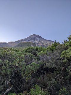
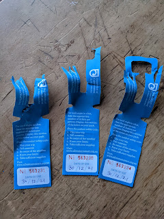
 When my Friesian friend had said, rats at the hut, he'd understated the situation. It was whole Small Animal Breeding Unit colony of rats. Weirdly what they most wanted were the three hut tickets looped as required on my pack. All night.  So I gapped it as soon as I could see. I needed to climb to the TV tower and follow the contour nortwestwards. I'll continue this post when I get more connectivity. Right, where was I? Heading for Holly Hut on Taranaki Maunga's northeastern flank. I passed a ranunculus, a sweet wee unnameable flower that is a candidate for my alpine trough, and volcanic cliffs. You can see the track running across the picture. It was in very poor condition, evidenced by stacks of materiel waiting for the track gang. Sometime after crossing under what I think was Hebberly Ridge/Minarapa Bluff, the old collapsed Pouakai volcano appeared, the floor now Ahukawakawa Swamp.  I reached Holly Hut at lunchtime, brewed a coffee, chose a bunk and kicked back with a

Stratford to Maketawa Hut

Image
  Wore a wool top as I left Stratford on Pembroke Road to walk about 10km uphill to my first stop, Stratford Mountain House. Never having been there before I had no preconception but a sign saying cafe open 9-late kept my spirits high as the road got steeper. Rural activism is a thing, I'm learning. This time I think a farmer is being accused of breaking up families and killing babies when he or she sends bobby calves away. After a while, I met the Egmont National Park boundary and just concentrated on the incline. Plus, I mentally sorted through all possible breakfasts and decided coffee and eggs would be the ticket. I reminisced about walking in Netherlands where every track leads to coffee or my Roman road hikes in UK which always ended in a snug pub, or do I mean pub snug. So at 0856hrs I sat on an outside chair in mild rain, tummy rumbling and quip ready for when staff opened the Mountain House. At 0902hrs I decided to storm the ramparts, or anyway the front door. Removed my b

Te Wera to Stratford

Image
  It was always going to be a long day, so I was out there on SH43 at 0530hrs this morning to crunch the remaining 35km to Stratford. Empty road, nice and cool and comfortingly domestic like this weedy bank. I climbed Strathmore Saddle and admired a house dating back to the earliest road. In turn I was admired by a handsome South American. At one stage I could see the road stretch for miles ahead (left to right in the background of this photo). So, I didn't look. Around midday I saw rooftops ahead and realised Toko might be an actual place, not like Strathmore or Douglas were behind me. Towns gutted by time and better roads. I fantasied about a corner store, a happy half hour wondering if there would be a bacon and egg pie or even an apple. I passed a village hall, a fire station, a derelict garage, Aitkens Transport, and on a corner the " Junction cafe bar". New, Cape Cod chairs on a verandah, exciting, closed. Rats. So I sat on their front steps and made my own lunch, w

Whangamomona to Te Wera

Image
  I walked away from The Republic of Whangamomona ("fong-or-more-more-nuh") at 0520hrs, wondering if I was crazy. All forecasters predicted rain so why not stay another night in comfort? Answer, to my own surprise, too boring. I had SH 43 to myself and made Whangamomona Saddle by 0700hrs. Cloudy and sweaty, but great to be striding out after 3 straight days of inactivity. Here, I watched a long tailed cuckoo being harried by a small dark indignant bird. Haven't seen a single whitehead (the host species) yet. Another saddle to climb, this time Pohukura and the choice of west on Junction Road or south to Stratford, and direct to Mt Taranaki.  South won. I saw a few wild goats, passed a few wandering cattlebeasts, smelled something lovely I couldn't find (twice) and walked in to Te Wera Camp about 5 minutes before the rain started. It's a former Forest Service rangers camp, now operated by an educational trust. It reminds me a lot of Glendhu Bay on Lake Wanaka. Sweet